Categories
Culture Other

The Thames path, Westminster to Putney

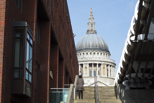
I talked about the juxtaposition of the C19th Gothic of Tower Bridge and the genuine medievalness of the Tower of London: not, in my opinion, one of the great planning decisions in the history of London. Well, at Westminster, you meet with a similar case. The Palace of Westminster (i.e. the Houses of Parliament), started in 1840, sits over the road from Westminster Abbey, started six hundred years earlier in 1245, and does its best to insinuate that it’s been there all along.

The fact that this revival of a five-hundred-old style occurred in the throes of the Industrial Revolution is fascinating to me. And at a time when wealth was moving faster than ever from the hands of the landed gentry to industrialists and merchants, and when reform was broadening democracy and extending the franchise, the symbolism of choosing a parliament building in a style associated with feudalism and religion could keep the semioticians busy for weeks.

Big Ben

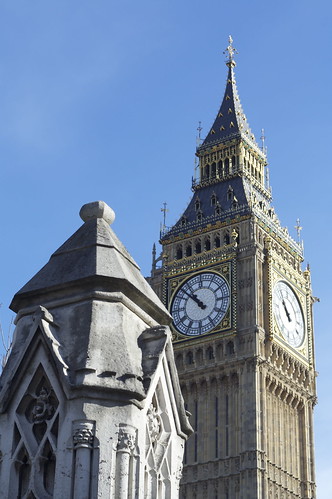
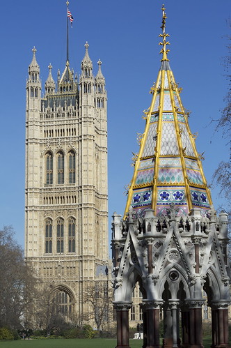
But symbolism aside, the finished result is far more successful than the Bridge/Tower combination. It helps that there’s a historical logic to it; it was after all built to replace the original medieval Palace of Westminster that burnt down in the 1830s, and it incorporates the medieval Westminster Hall. A lot of Victorian Gothic looks very Victorian indeed, because of the materials used or because a few Gothic motifs have been sprinkled on an essentially C19th building. And that’s no bad thing: much more interesting to reinvent a style for a new age than produce slavish reproductions. But in this case, given the location, I think it’s quite fitting that it does manage to look kind of ‘authentically’ medieval. Compared, for example, to the Buxton Memorial fountain marking the abolition of the slave trade:

Buxton memorial fountain

And if it slightly overshadows Westminster Abbey: well, it’s an important building. Having Parliament in a vast, grandiose, sprawling palace while the Prime Minister’s residence is an anonymous terraced townhouse must be better than the other way round.

Heading off along the river, the next major landmark is what I still think of as ‘the Tate’ but is now ‘Tate Britain’, thanks to Nicholas Serota’s empire-building and his ruthless crackdown on definite articles. And on the opposite side of the river, the building a friend of mine used to refer to as Ming the Merciless’s palace.

MI6 building

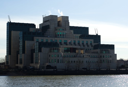
It is in fact the headquarters of the Secret Intelligence Service (MI6). I don’t know whether the architects were specifically asked for something that squats on the riverbank like a gigantic stony-faced toad, or if it just seemed appropriate. I remember reading once that it was supposed to look from air like the portcullis which is the symbol for the Palace of Westminster; thanks to Google Maps you can now see that it sort of slightly does.

The impact of it is somewhat diluted now by the presence just over the bridge of St George Wharf, the ugliest building in London. I remember quite liking St George Wharf when it was first built; during my lifetime, London (and indeed the UK) hasn’t always felt like a forward-looking, self-confident kind of place, and a boom in constructing big shiny new buildings was quite exciting in and of itself. But it just looks uglier every time I see it. I can’t think of a single nice thing to say about it. And St George Wharf itself is soon going to be overlooked by a 49-storey tower built by the same company. Yay. Vauxhall wasn’t exactly a site of outstanding architectural beauty before the developers got there, mind you.

Anyway, I crossed over Vauxhall Bridge because I wanted to do the next bit of the walk on the south side of the river; mainly because I wanted to go past London’s favourite white elephant, Battersea Power Station. I guess BPS isn’t very well known outside London except to Pink Floyd fans, but it’s an old friend to Londoners, particularly those who regularly take the train into Victoria from south London. It was designed by Giles Gilbert Scott, who also designed the Bankside Power Station which now houses Tate Modern. The building is protected because of its architectural importance, and since it stopped producing electricity in the 80s, a sequence of developers have supposedly been converting it to some other use (theme park, shopping centre, whatever). The cynical theory is that their plan is to let it deteriorate to the point where eventually the government lets them knock it down and stick up a load of apartment buildings.

Battersea Power Station

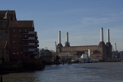
It was first built as a long narrow building with a chimney at each end (picture), and I actually think it was a more attractive building like that; elegant and cathedral like. But it was expanded in the 50s with a second turbine hall alongside the first, giving it its current upside-down table/dead dog look. Still, even if it messed up the proportions, it also made it much more striking and memorable. And if an impressive-but-ugly building sticks around for long enough, it eventually becomes much-loved. People even have nice things to say about the Albert Memorial.

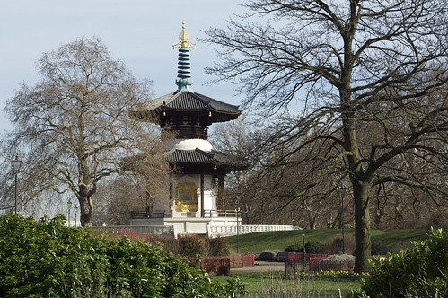
As it turns out, you can’t see the Power Station especially well from the Thames Path anyway; the path cuts inland to go around the Power Station site and the site is surrounded by hoardings that largely obscure it. You’d probably get a better overall view from the other side of the river. Still, it was quite interesting; it goes past the market at Nine Elms, where the wholesale fruit and flower markets moved when Covent Garden was converted to a tourist trap; some nice houseboats, including one which, in what I thought was a particularly stylish touch, had a lawn on the deck; a recycling processing plant; and then Battersea Park, which was really very nice on a sunny day. The park has all sorts of different areas, but where the path goes it’s laid out in little elaborately shaped flower beds surrounded by iron fencing and looks, to my eyes, like a very classic Victorian city park; oddly enough it made me think of Paris. It’s also the site of the London Peace Pagoda, a distinctly random but quite attractive feature added in the 80s.

London Peace Pagoda

Then I went back over the river across the Albert Bridge. I think this might be the most attractive bridge in London. It’s nowhere near as striking as Tower Bridge, but it’s a lot prettier, with its decorative metalwork painted white and picked out in pale blue, pink and pistachio. It’s frothy and whimsical. The signs reading ‘All troops must break step when marching over this bridge’ only add to the sense of delicate lightness.

The walk then takes you through Chelsea, now of course one of the most expensive bits of London, but as recently as the late C19th it was louche and cheap enough to be where all the artists lived. The Hoxton of its time. Whistler did lots of paintings of Chelsea and Battersea, of course, and his is one of the many blue plaques that you pass on this section of the walk.

This is the last bit of the walk which takes you along the Thames Embankment. All the way from Blackfriars Bridge, in the City, to Battersea Bridge, there is a road that sweeps along the north bank of the Thames; it would give it a fine boulevardesque quality if it was a just a bit more pedestrian-friendly. In fact there’s too much traffic for it to really make a good place for a stroll; flâneurs should head for the South Bank or one of the parks. What’s not obvious is that it’s entirely built over a sewer; all the piss and shit of west London accumulates under there and is carried off downriver. It was one of the great civil engineering projects of C19th London, and put a stop not just to the regular cholera epidemics but the smell.

I can think of nothing interesting to say about Putney at all.

» These pictures and others can all be found in my Thames Path Flickr set. If you just want to see the ones from this section of the walk, they are tagged thamespath4. I’ve also posted some photos taken on the walk to my photoblog, Clouded Drab; they are tagged Thames Path.

Categories
Other

More medievalish London

In my last Thames Path post, I commented that London’s medieval history is rarely visible except in the shape of a few street names. Which reminded me of something. When the Queen Mother (gbh) died in 2002, her coffin was laid in state in Westminster Hall for people to go and pay their respects. I was going to meet some friends for lunch, and when I arrived at London Bridge, I was startled to find myself at the end of the queue, which started in Westminster, went over the river, and ran all the way along the south bank. There was something about that moment that struck me as weirdly medieval; not just the fact that thousands of people were queuing to view the coffin of a dead royal, but the idea of a queue stretching from Westminster Abbey to Southwark Cathedral.

I know some people who think that the ceremony surrounding the Royal Family — the gold and ermine and glittery carriages — is the best reason for having them. And I can see the argument; it adds a bit of colour and texture to British life which is broadly harmless.

But it makes me twitchy. As long as the royals confine their activities to opening museums, launching ships, inspecting troops and so on, they don’t bother me at all. But all that pomp brings out the Oliver Cromwell in me. The symbolism of it all, of crowns and sceptres and thrones, of aristocrats in red robes and bishops in big hats is, well, medieval. In a bad way. And I know that very few people would admit to taking that symbolism seriously — it’s just a historical relic, right? — but it must surely have a powerful subconscious impact.

Though having said that, the massed pipes and drums of the Scottish and Irish regiments playing appropriately dirge-like music at the Queen Mother’s funeral were just fabulous.

» The photo is of the waxwork in Madame Tussauds. ‘The Queen Mother (Gawd bless’er)’ was posted to Flickr by xrrr and is used under a CC by-cc-sa licence.

Categories
Culture Other

Boy jumping

A crop out of the centre of a photo I shot on the South Bank the other day when I went to see the Rodchenko at the Hayward.

boy jumping

See also Phillippe Halsman and Jacques-Henri Lartigue. And of course Flickr.

Categories
Me Other

The Thames path, London Bridge to Westminster

A fairly short chunk of the path; I was intending to go a bit further, but the sun went in and I wasn’t really enjoying it much so I hopped on the tube at Westminster. Still, if you use one of the traditional definitions of a city—a town with a cathedral—this section includes the three medieval cities at the centre of London; it starts by Southwark Cathedral, goes past St Paul’s and ends at Westminster Abbey.

Just to explain that, because I guess not everyone knows the history of London: the royal court and the government was based at Westminster, separated by about a kilometere of fields from London, the mercantile and legal centre where all the law courts and guilds were based. The dynamic between the two is quite interesting, I think: London had a lot of legal autonomy (and indeed money) so even in the days of apparently absolute monarchs the balance of power was less clear cut than you might think. To this day when the Queen goes to St Paul’s for some kind of ceremonial function, her coach stops at the boundaries of the City of London and she asks permission to enter. As a South Londoner it pains me to say it, but Southwark wasn’t really much more than the overflow from London over London Bridge, although because of some kind of legal quirk that meant it wasn’t under the jurisdiction of London it became the centre for bear pits, whorehouses, theatres and similarly disreputable trades. Which is why The Globe was there.

bridges

That distinction between the mercantile City of London and Westminster as the seat of government has persisted, of course: we even still refer to ‘The City’ as shorthand for the banking and financial services sector and ‘Westminster’ as shorthand for parliament and government. I find these echoes of the longer history of London interesting because so little physically remains. The Great Fire of 1666 really did burn down nearly the entirety of medieval London. Much of it would no doubt have been knocked down anyway, whether by the Luftwaffe, town planners or commercial developers; but even things like the churches, which might normally offer that kind of continuity, were lost. And most of the Palace of Westminster burnt down in the C19th as well, so that was another major medieval building lost. There are still a few left: Westminster Abbey, Southwark Cathedral, the Tower of London, the Guildhall. But there’s no part of London you can visit and feel you’re in contact with what the city was like. The oldest part of the city is a business district, so it’s all office buildings. All that’s left is the street names: Old Jewry, Cripplegate, Milk Street, London Wall, Blackfriars, Hosier Lane, Carmelite Street.

What’s amazing is that London and Westminster remained separate up until about the mid C18th. So it took about 700 years for London to spread the one kilometre westwards to reach Westminster; but in the next 150 years it spread something like 10 km in all directions.

St Paul's from the path

Anyway, you may be wondering why I’m wittering on about the history of London instead of talking about the actual walk. It’s because I didn’t find it very interesting. I decided to walk the north bank because I more often go along the southern side, because of Tate Modern, the South Bank Centre and so on. There quite a few theoretically interesting things to look at: war memorials, the Millennium Bridge, Cleopatra’s Needle, a glimpse of St Paul’s and a couple of the Christopher Wren city churches, as well as views of Tate Modern, Shakespeare’s Globe, the South Bank Centre, the London Eye, the Oxo tower. And just at the end, Big Ben and Portcullis House. But it’s all very familiar; and the path goes past the City and the West End without actually having much contact with them.

It doesn’t help that if you’re walking the north bank in winter, the light is coming from over the river all the time. So everything on the other side of the river was backlit and dificult to photograph; and I really need a wider-angle lens to take pictures of buildings near me.

» Once again I’ve added the pictures to my Thames Path set on Flickr; these ones are tagged with thamespath3.

Categories
Culture Me Other

The Thames path, Isle of Dogs to London Bridge

I picked up the Thames path where I left off, in Greenwich, and crossed straight under the river to the Isle of Dogs. The Greenwich foot tunnel itself is kind of freaky; I’m not normally susceptible to claustrophobia, but I got a definite twinge here. I took the stairs down, which made me conscious of how deep underground it was; and then the tunnel is quite narrow, and feels surprisingly long. And if you start thinking too much about the mass of the Thames sitting above you…

Anyway, the Idle of Dogs [sorry, that’s a typo, but it would make a good title for something, don’t you think?]. I mentioned that during the last section there were occasional outcrops of upmarket apartment blocks among the industrial landscape. As far as you can tell from the Thames path, on the Isle of Dogs that process is now complete. The riverfront is almost completely residential for this section of the walk. And the exceptions are offices rather than industry. It’s a dramatic change, since this was once one of the greatest trading centres in the world. The docks are still there, huge stretches of water now serving as watersport centres, or marinas, or just gigantic decorative water features; and many of the wharves and factories have been adapted into apartments and offices. But it’s remarkable how little these physical traces of the past give any sense of what it must have been like. In the absence of noise and smell and dirt, with no real traffic on the river, the old hoists that have been left on the sides of converted warehouses just seem like some peculiar local architectural vernacular: steampunk genteel.

river front

The buildings I found most attractive were those which seemed to have an intimacy with the river. That usually meant converted wharves. Not just because they’d had the chance to weather and age into the landscape, but because they’d been built right up on the river, overhanging the water. The new-built apartment blocks are quite different. In some ways, the river is the reason for their existence; they were built where they were because the developers know people will pay good money for a river view. But it’s a view. The river is something they look over and look across. It could be anything; as it happens, it’s a river. The apartment blocks don’t even have a relationship with each other; the Thames Path regularly has to leave the river to skirt around buildings not because they are physically blocking the way, but because they have big walls and fences covered in private property signs. I understand the desire for security, but there’s something faintly depressing about a whole row of apartment blocks all treating each other as the enemy.

Just occasionally you find a corner that gives you an idea of what this part of London could have been like: a city on the water, a kind of Venice with docks replacing the canals. Perhaps Venice is a bit optimistic, but the redevelopment of a whole area of London has to be an opportunity to do something remarkable; on the whole that opportunity has been wasted. Not that the area is a disaster; hell, I wouldn’t mind one of those apartments with a view of the river for myself. But it’s not a triumph, either.

apartments reflected in water

The most striking collision of architecture and the water is Canary Wharf, where from the right angles, the skyscrapers seem to rise out of sheets of water. Which is spectacular, in a 60s-vision-of-the-future sort of way. I remember when it was just the Canary Wharf Tower standing alone, then the tallest building in Europe, towering over the area. It had only just been completed when the property market collapsed, and it stood half-empty for a long time. You used to be able to see it from all over south London. In the post-binge guilt of the early 90s, it seemed like a visible symbol of the greed and hubris of the 80s. Now, with Canary Wharf a major centre for London’s financial industry, and a whole rash of big new tower blocks planned for London, that original building seems ahead of its time; visionary, almost. Timing is everything. Since it looks like we’re about to have a serious economic downturn, the builders of all those new super tall skyscrapers may that find out the hard way.

After lunch, I went down to rejoin the river and was startled to find myself looking at Tower Bridge. You wouldn’t think something like that could creep up on you, but the geography of the river is such that I hadn’t seen even a partial view of it until going round the bend in the river at Wapping. And next to Tower Bridge, the Tower of London. Just as it’s hard to get a sense of the industrial past of the Isle of Dogs, it’s hard to think of the Tower as a military installation and prison. I believe the tour guides do their best to play up the gorier elements of the Tower’s history, but on a day with the sun shining on the honey-coloured stone walls and tourists wandering aimlessly around, it’s hard to think of the building as the Lubianka of medieval and Tudor London. Tower Bridge doesn’t help. I think I’ve mentioned before how odd I find the juxtaposition; the genuinely medieval Tower right up against the Victorian medieval pastiche.

girl in sun

It says something about the self-confidence of the Victorians that they built the bridge there at all; the Tower is one of the most historically important buildings in the country, and the bridge is right up against it, looming over it. The Gothic styling on a cutting-edge piece of engineering just adds to the intrigue. I’d love to know what the planners thought they were doing. Did they think that it would make the bridge complement the Tower? Or were they just following the fashion of the moment? If they did intend it to be a sympathetic piece of design, I think they failed. The two are too close, too much in competition. It almost feels like the bridge is poking fun at the Tower. Don’t get me wrong, I think that Tower Bridge is a fabulous construction. It’s the complete opposite of a purist’s bridge. I think bridge aficionados typically enjoy a kind of engineering aesthetic, where the beauty arises from the structure; the builders of Tower Bridge clearly had no time for such asceticism. And the result is slightly bonkers. In fact I think it’s only familiarity that stops us from seeing how bonkers it is; but it didn’t become one of the most easily recognisable bridges in the world by being normal.

» Once again, these photos and others are posted to my Thames Path set on Flickr. I’ve tagged all the ones taken on this section with thamespath2.

Categories
Me Other

The Thames path, Charlton to Greenwich

The Thames Path is what it sounds like: a walking route that follows the Thames. It runs 184 miles from the source in the Cotswolds to the Thames flood barrier. I walked from the Thames barrier to Greenwich. My plan is to do the London part of the route in occasional sections; I’m not planning to walk all the way to Cirencester. Though it might be quite an interesting long-term project.

Thames Barrier

The section I’ve just done started at the Thames Barrier itself and went along the south bank, looping around the Greenwich peninsula past the Millennium Dome, with all the skyscrapers of Canary Wharf just over the river, and ended by going past the Royal Naval Hospital.

Despite the engineering marvels of the barrier and the dome and the shiny pointiness of Canary Wharf, it really was not a glamorous walk. The shipping which once would have made that stretch of river one of the busiest in the world now goes into more modern, deeper ports that are equipped to deal with container ships, and heavy industries have largely moved overseas, but despite a few outcrops of upmarket apartment blocks it’s still a working part of London. I noticed a Tate and Lyle factory, probably making sugar from EU-subsidised sugar beet, and an aggregate recycling plant; there were various yards that seemed to be stockpiles of gravel and sand for the construction industry. But most of the time I had no idea what businesses I was passing. I would guess some were chemical processing plants; at other times I was probably just passing behind warehouses. It was dusty and sometimes smelly, and for several sections of the walk the Thames Path ran between eight foot high chain-link fences, and felt like a peculiar and frivolous intrusion on the area.

bit of industrial stuff

Even so, it wasn’t without bits of wildlife. There were little groups of teal on sheltered spots all along the river, and hundreds of gulls. And hopping around in that most urban of shrubs, a dust-covered buddleia,
was my best bird of the day: a chiffchaff. These little greeny warblers are supposed to be in Africa at this time of the year, but a few stay for the winter. The RSPB suggests 500-1000 birds overwinter here compared to 800,000 pairs in summer.

gulls

I won’t be rushing to walk this route again—once was enough—but it was interesting, even so. From here on I have a choice of which side of the river to take, so I think I’ll probably cross over the river (well actually under the river, via the Greenwich foot tunnel) and walk around the Isle of Dogs side as far as London Bridge.

» I’ve started a Flickr set of pictures from the Thames Path. All the pictures in this post come from there. I’ve also posted a picture from the walk to Clouded Drab.