I really use the maps on my phone a lot. I’ve found it to be the most surprisingly transformative aspect of having a smartphone: never feeling lost.
So I was slightly worried about Apple replacing Google’s maps in the new version of iOS, but I assumed they knew what they were doing. That it might not be perfect, but it would probably be good enough. So I updated the system.
Obviously the first thing you look at is your own street. And it was a bit disconcerting. The first thing I noticed was a ‘restaurant’ which was actually a food shop and has been out of business for perhaps seven years. There is also an antique shop which no longer exists, and a food shop marked as a petrol station. A car repair place is 250m from where it should be. Completely missing are two restaurants, a café/delicatessen, a clothes shop, a gift shop, a car repair place, a barbers and a post office. And the local primary school.
To be fair, there also four businesses listed correctly.
Now, I don’t actually need every little clothes shop marked on the map, and the data being a year or two out of date is not such a big deal, but still, that’s an awful lot of wrong in a small area. As a comparison, Google has all the businesses marked, up to date and in the right places.
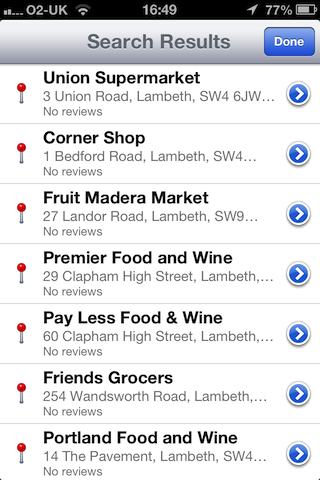
And it’s not a fluke. For example, the ‘food shop marked as a petrol station’: that’s true all over London and seemingly the rest of the UK as well. Almost everything marked with a little petrol pump icon is actually a food shop — although I have also found oil companies, a wholesale kerosene supplier, and a nuclear fuels company. And it’s not just the icons which are wrong; a search for ‘petrol station’ or ‘gas station’ dutifully returns a list of local food shops:

If you’re wondering what real petrol stations are marked as, I checked a few nearby ones; one was marked as a mechanic, two were missing completely.
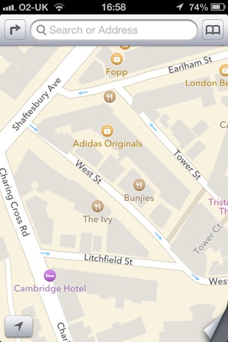
Irritating but not fatal is the fact that the outlines of buildings in Central London don’t align properly with the roads:

And my favourite find so far is something called the National History Museum in South Kensington.
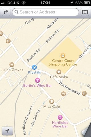
However, I don’t use maps on the phone as a business directory, primarily. It would be helpful if things like petrol stations, post offices and ATMs were correctly marked, and it’s a step backward that they aren’t; but what really matters is whether I can use the maps for basic navigation. But there’s a bigger problem than a few missing businesses. I checked a few places I regularly visit. If you don’t know the area, it may not be obvious what’s wrong with this picture (apart from yet another corner shop marked as a petrol station):

The clue is ‘Station Road’. Yup, that map is centred on Wimbledon station. There should be a National Rail station, a London Underground station and a tram station marked there — not that Apple’s maps give you any way to distinguish between train stations and tube stations.
Richmond rail and underground stations are also missing. So is Bookham station in Surrey. So is Lambeth North underground. And Notting Hill Gate. And West Dulwich.
I should emphasise: I haven’t done an exhaustive search of London’s transport network, I just checked a few places I happen to use fairly regularly. And without trying very hard I’ve found six missing stations.
A map having a bit less detail, or missing a few restaurants: that’s mildly annoying. Not being able to find petrol stations and post offices: genuinely inconvenient. But a map with a significant percentage of train stations missing is severely broken. Broken enough that you can no longer rely on it for anything important.
I suppose I should just be grateful that the roads themselves seem to be mainly in the right places — but I suspect we mainly have Ordnance Survey to thank for that, after they released so much data under Creative Commons-type licensing.